Antarctic ice dynamics
Thursday seminar was by Dr. Paul Tregoning this week, titled “The melting of Antarctica and rising sea levels: What do we really know?” I will try to summarize, but since it is mostly geophysics, it will be a simplified explanation. Never-the-less, there are important lessons from the talk about how we know what we know, and where limitations of knowledge come from.
But first, a basic geophysics refresher: Isostacy.
Unlike the smaller, deader terrestrial bodies in our solar system, the Earth has a weak lithosphere. This means that if you put a large weight (like an ice sheet) anywhere on Earth, the weight will deform the planet. Specifically, the weight will sink, and displace the underlying mantle, until the total mass where the ice sheet is equals the mass everywhere else. This even distribution of mass around the planet is known as isostatic equilibrium, and if rapid changes on mass occur (e.g. an ice cap melts), the mantle will flow to achieve a new equilibrium.
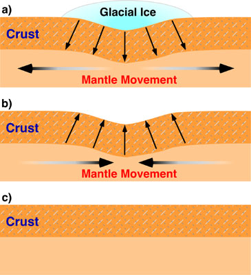
Figure from http://www.physicalgeography.net/
The problem is, the mantle doesn’t flow very quickly, being solid rock and all, so it takes tens of thousands of years to reach equilibrium. In fact, areas that were heavily glaciated during the last ice age are still rebounding today.
Back to Antarctica.
The talk focused only on current ice trends, and only on Antarctica, not Greenland. In Antarctica, there are two main satellite methods used to look at the ice volume. Altimetry, which measures the distance of the top of the snowpack to a satellite in known orbit, and gravity, which measures the total mass change of the ice sheet.
In both cases, the measurements are not straight forward. Altimetry measurements are dependent on snow thickness, freshness, slopes, etc. Gravity measurements appear to be dominated by artifacts, and various researchers are not in agreement on how to make sense of the data.
Satellite data analysis was not the focus of the talk, but he did mention that there was a French approach and an American approach- the French used an empirical noise reduction that the Americans claim has no rigorous basis, and the Americans use a Gaussian technique that the French think removes signal along with the noise.
No matter which technique you use, the gravity data shows mass loss in coastal West Antarctica (Marie Byrd Land), and mass gain in Enderby land and the Zumberge coast region of SE West Antarctica. And that’s where things got interesting.
Everyone agrees that the mass loss in coastal Marie Byrd Land is ice loss- the only argument is whether it is increased ice flow/melting or drought (reduced snowfall). But there are two possible explanations for the mass gain in the other two locations. One is that snowfall has increased, so the ice mass is increasing there. The other possibility is isostatic rebound.

Although Antarctica is still glaciated, in some parts the glaciers are thinner now that they were during the last ice age. Thus, rebound is a possibility. And because the mantle is 3.6 times denser than ice, you need a lot less rebound to get the same gravity signal. And various modelers suggest that the rebound signal could be between 80% and 120% of the ice mass signal. But there are a few problems.
Firstly, there are very few points where the rebound history of Antarctica can be measured, because most of it is still under ice. The Scandinavian ice sheet has hundreds of paleoshorelines that can be used to construct a rebound history. Antarctica- which is larger than all of Europe- has lass than a dozen good sites.
Furthermore, attempts to calculate what the ice thickness of Antarctica was at the Last Glacial Maximum are similarly vague- most of them consist of taking the total sea level change, subtracting out the comparatively well known Northern Hemisphere ice volumes, and assuming that most of the rest of the missing water mass must have been ice in Antarctica- somewhere. And many recent field studies seem to complicate many accepted models of where that extra Antarctic ice could be stashed.
In the case of the Zumberge area, consensus seems to be that it is isostatic rebound that is causing the mass gain. But in the case of Enderby Land, it could be either. So this last summer field season, they put in a remote GPS station to get ground-truth data on whether or not the bedrock is rebounding. If there is significant rebound, then there may not be any substantial precipitation gain to offset the ice loss from West Antarctica. If there is no rebound, then the net mass loss from the Antarctic ice sheet could be considerably smaller. It takes about a year or two for a GPS station to get enough precision to determine uplift rates needed to constrain this data.
Overall, it was a very good talk, with the speaking being exceptionally careful to explain where various constraints came from, and how we know what we know (or don’t know). And he did a great job of not getting drawn into unrigorous extrapolation or editorializing during the question and answer session.
4 comments:
nice summary...
with regards to the other possibility being increased precipitation...did the speaker mention if we have any direct measurements for that part of Antarctica?
Do rain gagues work in Antarctica?
They didn't mention anything about direct measurements, but I don't think there are any stations out there. In any case, precipitation measurements don't tell you if there is a change in speed the ice beneath is flowing away.
The speaker was an isostasy guy, so he stuck to what hew knew, with just enough of the other stuff to give us the big picture context.
Can RADAR be used to figure this out? I mean, we can now see something like a kilometer into the surface of Mars, right? And, we can at least near surface water ice in this data. And, there's very little ground truth on Mars.
The problem is that you need mm to cm precision in an ice sheet that is several km thick, and that doesn't have a flat bottom. I don't think ice penetrating radar can do that yet, if ever.
Post a Comment